Struggles over finite space are endemic to urban life, but in San Francisco the battles can be especially fierce. As a peninsular city, its geography alone limits its capacity to absorb newcomers, a constraint exacerbated by extensive regulatory obstacles to building new housing. Most recently, the influx of monied home buyers from Silicon Valley tech companies has transformed and gentrified entirely new areas of the city, such as the Mission District. The process has sparked more than a little tension as longstanding residents find themselves priced out.
More than a century ago, as an earlier battle played out between San Franciscans new and incumbent, the city’s Board of Supervisors took a very active role in deciding who San Francisco should be for. Their effort resulted in a bizarre but intriguing map designed to convey the grave and imminent “threat” posed to native San Franciscans by one emerging neighborhood in particular: Chinatown.

The Chinese were—like all Californians at the time—recent arrivals, attracted by the gold rush and the subsequent demand for labor to complete the Central Pacific Railroad. When the railroad was finished in 1869, many Chinese immigrants migrated to San Francisco, and by 1880 they constituted over 10 percent of the city’s population. Initially, Chinese residents and businesses had been dispersed throughout the city, but gradually they coalesced into a 15 square-block area of the city known then and now as “Chinatown.”
The Chinese influx came while the city was at the sharp end of a recession that had afflicted the entire nation. In this context, Chinese workers so desperately needed during the boom just a few years earlier became scapegoats for the economic crisis. The first anti-Chinese group formed in 1867, and by the 1870s this hostility was strong enough to sustain a new political party—the Workingmen’s Party—which set its sights on removing the Chinese “menace.” Attacks and anti-Chinese riots spread in the 1870s and 1880s.
It was a small step from blaming the Chinese for the city’s economic condition to blaming Chinatown for the city’s public health. Throughout the 1870s Chinatown was on watch, subject to routine surveillance and ongoing investigations. But San Francisco was not alone in such hostility: California’s virulent campaign against the Chinese ultimately resulted in the nation’s first restrictive immigration legislation in 1882. Ironically, however, the Chinese Exclusion Act made Chinatown even more attractive, as one of the few (relatively) safe havens against the persecution that Chinese immigrants experienced throughout the west.
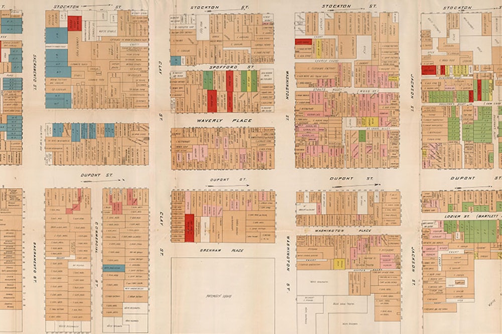
As the neighborhood’s population grew, so did the panic among San Francisco’s fathers, who commissioned a massive civic inquiry in 1885. The resulting report is still shocking to read for its extreme characterizations of the Chinese “race,” which the authors deemed to be “the rankest outgrowth of human degradation that can be found upon this continent.” To convey the severity of the perceived crisis, the report’s authors also compiled an extraordinary map of vice. As I’ve written elsewhere, this map was part of a larger, nascent trend in using maps to measure the population in multiple ways, from income to education, religious practice to ethnicity. But I’ve never seen a map so relentlessly focused on vice. The legend alone gives us some sense of the contemporary perceptions of the Chinese. With beautiful and clear color codes, the map identifies the many businesses that flourished in Chinatown, but highlights houses of prostitution, opium, gambling, and pagan worship (known as “Joss Houses”).

The beauty of the map, with its ornate lettering and finely executed color, is very much at odds with the ugliness of its content and intent. A small version was originally inserted in the report, but quickly reproduced on a much larger scale (seen here), measuring approximately two feet high and five feet long. The overall effect is ironic: the report describes the neighborhood as an anarchic den of iniquity, yet the map renders it in pleasing and orderly color.

The map makes clear that it only shows the street floor of each establishment, while the report goes to great lengths to catalog the sins committed in the labyrinth below. The authors described residents “living scarcely one degree” above waterfront rats, in unimaginably filthy and disastrously crowded conditions. Instead of families, the investigators found the sexes largely living separately, with men sleeping in shifts in bunks crammed into lodging houses while women were enslaved as prostitutes. Perhaps even more horrifying to the investigators was the explosion of white prostitution to meet the demand for sex, and the map takes pains to separate white prostitution (colored blue) from Chinese prostitution (colored in bright green).


There was of course nothing unique or even new about anti-immigrant sentiment in America in the 1880s: the Chinese were only the latest victims of an economy that alternately devours and then scapegoats cheap labor. Today, the same neighborhood that the city’s fathers deemed a threat to San Francisco continues to thrive, a mecca for tourists and the largest Chinatown outside of Asia.
