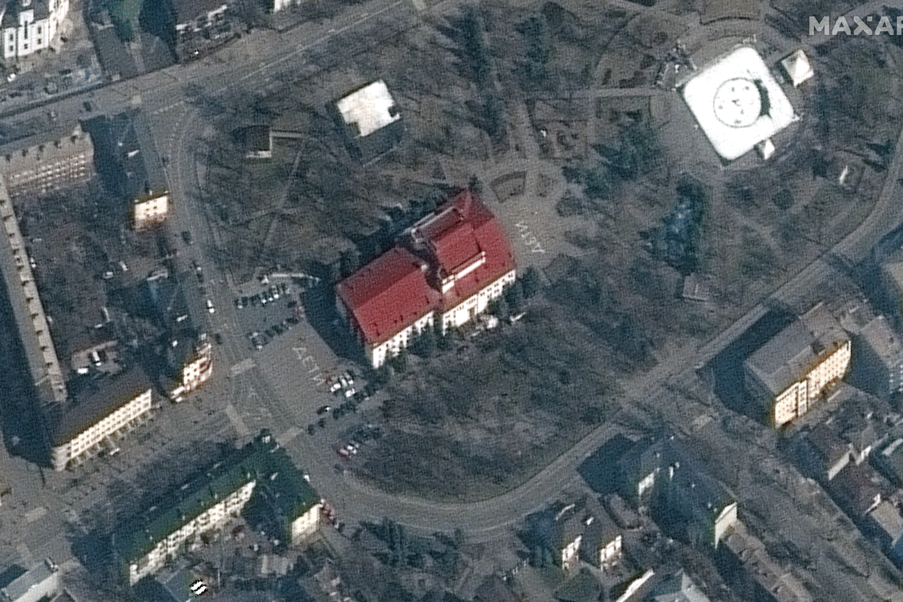
On February 20, the Russian Parliament had not yet authorized President Vladimir Putin to use military force outside the country, and Ukraine had not yet declared a state of emergency. In a television interview that day, Pentagon press secretary John Kirby maintained that Putin “has not conducted another invasion in Ukraine yet, and we still think there’s time to prevent that.” But to anyone who believed an invasion was imminent, the view from space seemed to prove it.
On CNN, satellite images revealed that, according to the chyron, Russian ground forces were headed toward the Ukraine border. Some of the photos clearly showed Russian military activity, including lines of tanks. But some of the photos showed only tire tracks in the snow and could have been mistaken for abstract paintings—or carpeted floors, as one Twitter user quipped. CNN anchor Pamela Brown asked retired Army General Mark Hertling for his perspective: “What do these images tell you?”
“Well, they’re still images,” he said, then hypothesized that they showed a military unit entering a staging area or headed “to an attack position. That is probably what’s going on. But you can’t just take the single images and draw a conclusion from it.” Military analysts, he said, would consider satellite images alongside “signals intelligence,” “moving targetry,” and “human intelligence from the ground.” But in Brown’s view, the satellite images looked like a definitive portent of war—“a picture putting all the intelligence together.” She asked another analyst to speculate on whether the images bolstered the belief of U.S. officials that “orders have been given to [Russian] commanders to proceed with an invasion.”
This was a high degree of certainty to draw from a series of largely nondescript photos, especially given that Brown didn’t explain their provenance. In fact, Brown didn’t even mention the company that captured and provided the photos. But if viewers looked closely at the top-right corner of the frame, they could see the name for themselves: Maxar. And only if they bothered to look up the name, as few surely did, would they have learned that Maxar Technologies is the Department of Defense’s top geospatial intelligence contractor—a multibillion-dollar company whose relationship with the mainstream media is nearly as cozy as its relationship with the U.S. government.
While the satellite images of other companies have also made their way into the press coverage of Ukraine, none have been as ubiquitous as Maxar’s. The same photos that appeared on CNN on February 20 appeared in dozens of other outlets, including The New York Post, The New York Times, and Reuters. Since then, hardly a day has gone by without a national outlet featuring Maxar images, most prominently of the bombing of Mariupol (NPR, USA Today, The Guardian) and the destruction of a theater where civilians allegedly were sheltering (NBC News, Business Insider, The Washington Post). Axios has frequently featured Maxar images in its coverage of Ukraine, with stories often bearing the headline “Satellite images show.…” “If you’ve seen high-resolution satellite imagery published in connection with an important story, that image was more than likely taken by a Maxar satellite,” Maxar president and CEO Dan Jablonsky said recently.
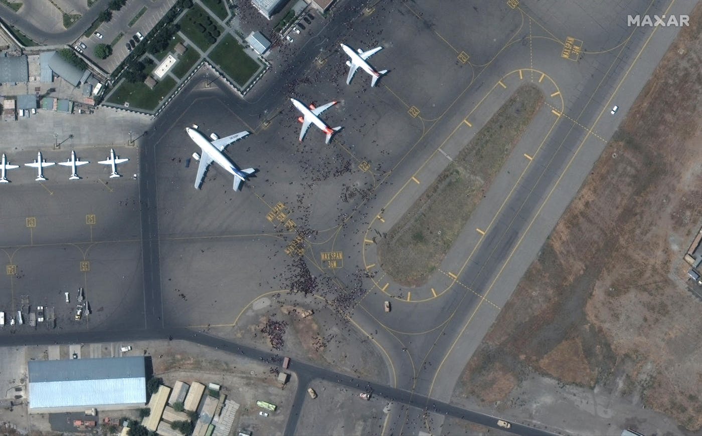
This is due, in part, to the persistence of Maxar’s News Bureau, which has promoted the company’s images, analytics, and experts to leading media organizations around the world, for no charge, since 2017. The reach of the program is vast. Images of the chaos at the Kabul airport during the U.S. withdrawal from Afghanistan last year were shared in more than 700 publications, according to Maxar; the number of publications that have used Maxar images from Ukraine may well be higher. Media outlets, eager to wring clicks out of free content, sometimes simply post photo galleries of images that the company distributes en masse. But reporters also have used Maxar’s services to conduct award-winning investigations on, for instance, the expulsion and murder of Rohingya Muslims in Myanmar, a chemical attack by the Assad government in Syria, and murders perpetrated by Cameroonian soldiers.
Maxar boasts that the News Bureau is a vehicle for “social good and global transparency,” offering services “that are powerful complements to good journalism, providing indisputable truth at a time when credibility is critical.” The company’s images have indeed proven an effective tool; during the buildup to the war in Ukraine, they’ve served as an important counterpoint to Russian disinformation. But Maxar is by no means a neutral player when it comes to global conflict, and thus there are limits to what these images alone can tell us. Sometimes they may provide not an “indisputable truth” but a distorted understanding of the story.
Maxar’s history dates back to the birth of the American commercial satellite imagery industry in the 1990s, which was made possible in part by President Clinton’s decision to open up the sale of images to foreign entities. Five years later, a company called Space Imaging launched Ikonos, which The New York Times described at the time as “the world’s first private spy camera.” After several acquisitions and a merger, Maxar was born, in Westminster, Colorado, in 2017.
Jack O’Connor, the director of the Master of Science in Geospatial Intelligence program at Johns Hopkins University, said the U.S. government supported the industry from the beginning by sharing the costs for the development of new commercial imagery satellites. “They were cutting the defense budget, and they wanted to retain the capabilities in the industry. They didn’t want the industry to die,” O’Connor said. In the decades since, the U.S. government has consistently contracted with commercial firms to supplement its own satellite images. The company now has a growing number of competitors, but for many years, O’Connor said, “Maxar was the only game in town.”
Maxar’s defense capabilities—including satellite imagery, mobile access terminals, precision 3D registration technology, and artificial intelligence and machine learning capabilities—were developed with the needs of the U.S. government and its allies in mind. Today, the U.S. government remains a critical Maxar customer. According to Maxar, the company provides 90 percent of the “foundational geospatial intelligence used by the U.S. government for national security.” For nearly a decade, Maxar was the sole supplier of commercial high-resolution satellite imagery for the Defense Department’s National Reconnaissance Office, which paid Maxar $300 million per year for access to its satellites as well as its behemoth image archive.
As a Maxar customer, the Department of Defense isn’t just a passive consumer of Maxar images; it is, in a way, a co-producer of those images. “These satellites don’t just go around and around the world taking pictures and adding them to their archive,” said Laura Kurgan, the director of the Center for Spatial Research at Columbia University. Maxar’s satellites often take photos when—and where—they are tasked by the company’s customers to do so. “Once tasked, those images are archived, and anyone can purchase them,” Kurgan said. Maxar can also share those images with the press. But crucially, Kurgan says, the media organizations in Maxar’s News Bureau network will “never know who tasked the image,” including when the tasking customer is the U.S. government. In other words, media outlets can unwittingly funnel images to the public that were specifically ordered by the U.S. government, without those outlets, or the public, knowing it for certain.
According to industry experts, this is not an accidental by-product of the U.S. government’s need for geospatial intelligence but a key benefit of working with commercial providers, since the images the government takes with its own satellites are classified. “What they love about commercial providers is that the images are freely shareable,” Chris Quilty of the market research firm Quilty Analytics told SpaceNews. That’s especially useful in times of war. For instance, Quilty said, “if commercial imagery didn’t exist, you would have had the U.S. administration waving their hands about the Russians massing troops around Ukraine,” and they would have been unable to provide the visual evidence to back up the claim.
But just as the U.S. government can work through commercial satellite imagery companies to reveal information strategically to the public, it can also use its power over those companies to conceal information. One way it can do that is through “checkbook shutter control.” In the fall of 2001, after reports of heavy civilian casualties from American bombing in Afghanistan, the federal government spent millions to buy the rights to all Ikonos image data over the country for two months. Since Ikonos had the only high-resolution photographs of the area on the U.S. market, according to Wired, the government’s purchase made it “functionally impossible for anyone else to use commercial US imagery [to] surveil the area.” The media, like everyone else outside the U.S. intelligence community looking to get a high-resolution satellite view of the war, was largely out of luck. (The Pentagon allowed select Ikonos images to be sold to the media.)
Maxar’s images don’t need to be censored, necessarily, for the company to provide an incomplete view of global conflict to the press. While Maxar’s status as a defense contractor lends its content a certain legitimacy, the images it provides to the media are not, in fact, “as precise or as timely” as the images the U.S. military itself collects, retired Navy Admiral James Stavridis told the Associated Press. When U.S. military and intelligence agencies do turn to Maxar images, they corroborate them with intelligence from human sources, real-time video, and information collected by spy planes. With Maxar images alone, you can “see something on a base that looks like a base that has a lot of activity,” Hans Kristensen, director of the Nuclear Information Project at the Federation of American Scientists, told the AP. “But in terms of what’s being done there, and what the units are—that takes a lot more intel.” News audiences looking to Maxar’s images to understand war will likely never view them in the fuller context to which military analysts are privy.
Those viewers will also never see a complete picture of global military activity. Maxar does not show U.S. troop movements to the public but often releases images of U.S. adversaries like China and Iran. The result is an asymmetrical view of geopolitics—one that, according to Cory Wimberly, an associate professor at the University of Texas Rio Grande Valley who wrote a book about corporate propaganda, is a kind of manufactured siege mentality. In this scenario, news consumers are led to believe that the U.S. is constantly under threat and in need of military solutions—which, not incidentally, requires the military to use more of Maxar’s services. Jablonsky has said that the company is “hopeful for a peaceful resolution” in Ukraine. But it is also positioning its offerings to support the Defense Department’s pivot “from anti-terror missions” to confrontations with “large, near-peer adversaries”—namely, Russia and China. “If the way that you make your money is through conflict and war, then you’re going to be looking for opportunities to become involved in conflict and war,” Wimberly said.
Satellite imagery is a substantial part of Maxar’s business, which also includes the design and manufacturing of satellites and spacecraft components. In 2021, Maxar’s Earth Intelligence capabilities generated $1.1 billion in revenue—nearly 62 percent of the company’s total revenues. In addition to its contracts with the U.S. government and its allies, the company also works with nongovernmental organizations and for-profit companies. (Google Maps and Google Earth, for instance, rely on Maxar satellite imagery.) The company doesn’t publicly disclose how much of its revenue comes from providing satellite imagery specifically to defense customers. But according to a recent Maxar annual report, the “loss or reduction in scope of any one of our primary contracts” with governmental entities would “materially” reduce the company’s revenue.
Amid the crisis in Ukraine, that possibility doesn’t seem likely. Maxar’s profile, in fact, is looking rosy lately, according to Rich Smith, a contributing analyst for The Motley Fool who focuses on the defense and aerospace industry. On February 28, shares of Maxar Technologies spiked 13.5 percent, and there was “no obvious news” to explain the jump, Rich wrote, “except for the most obvious of all: Crisis in Ukraine.” According to Smith, the proliferation of Maxar images of Russian troops boosts the company’s name recognition, which is likely capturing the attention of investors. In a February 22 earnings call, Jablonsky acknowledged that the company had in the past “seen benefits from geopolitical events of the type we’re seeing now heating up.” Asked whether the uptick in press involving satellite imagery in the “current geopolitical environment” had presented “any new opportunities or benefits” on the “commercial side” for Maxar, Jablonsky praised the company’s chief marketing officer and the News Bureau team, noting that while the “situation itself is tough,” their work has highlighted “the importance of the types of services and products we provide as well as the quality and accuracy of the data that we’re doing.”
Maxar is not the only geointelligence company poised to benefit in an increasingly surveilled and militarized world. The $9 billion geospatial imagery analytics industry is expected to grow to $37 billion in the next four years. Scott Herman, CEO of satellite software company Cognitive Space, told SpaceNews that “the conflict in Ukraine and its global implications create an opportunity for the new Earth observation space companies to demonstrate their capabilities.” Maxar appears eager to seize the moment, especially as it seeks customers ahead of the launch of its next-generation WorldView Legion satellites later this year. A tweet from the company on February 28—the same day its stock jumped—featured a widely circulated image from the Kabul airport evacuation, altered to include a target-like box in the center of the frame. “Precision delivered!” the tweet read. “When there is no room for error, organizations partner with us for trusted #hardware, #data and #insights needed to keep their operations going.”
“Through our News Bureau initiative, and of our own volition, Maxar has made much of this imagery available to news organizations to support global transparency and combat the spread of disinformation,” Jablonsky said in a statement provided by email to The New Republic. “We are proud of our contributions to the public discourse around this tragic situation and will continue to share imagery to document the invasion and resulting humanitarian crisis.” Maxar denied a request for an interview.
There is no such thing as a neutral image—and that’s no less true of a satellite image. But Sean Aday, an associate professor of media and public affairs at George Washington University, says that news audiences can often ascribe a greater sense of authority and objectivity to satellite images than other kinds of photos. “Because they have this sort of high-tech side to them, there’s a way in which audiences might be even more likely to take them at face value.”
A commercial satellite image is very good at providing a broad picture of a location the military is looking to surveil, attack, or defend, but it’s incapable of providing closeups of people on the ground—and thus risks stripping them of their humanity. Maxar’s images of the “chaos” at the Kabul airport, for example, effectively communicate the evacuation as a security situation for the U.S. military to manage; they entirely fail to communicate the desperation of the Afghans looking to flee a country in free-fall. From space, in fact, the Afghans at the airport don’t look like humans at all but rather tiny dots scattered across a tarmac. “It looks like pepper has been sprinkled on the airport,” said Lisa Parks, a professor of media studies at the University of California at Santa Barbara. “Though it is a humanitarian crisis, it doesn’t look like one.”
Some news outlets provide additional context when using Maxar images. For instance, the Times supplemented a Maxar-driven photo essay on the Kabul airport evacuation with videos from the ground. But caveats or disclaimers about the content of Maxar’s images—such as a February AP story noting that “commercial satellite images, as a snapshot in time, do not provide indisputable evidence of exactly what the Russian military is doing or why”—are rare. In the last several weeks, Reuters has frequently run Maxar images that purported to show Russian troop movements without providing any other images for comparison. The only source to weigh in on Maxar’s images in one of those stories was Stephen Wood, the head of Maxar’s News Bureau, who explained that the images indicated “an increased state of readiness.” A Reuters spokesperson told The New Republic via email that the outlet “publishes handout images provided to the media by third-parties … when we determine the images are newsworthy and typically when they are the only source of such visuals.… As is the case with Maxar, publishing images from third-parties is in no way an endorsement of their organization nor does it signify that Reuters has any further relationship with them.”
While Wood’s statement may have stoked fears of Russian aggression, it didn’t explicitly make the case for U.S. military intervention. But members of the press who do want to make that case can find visual ammunition in Maxar images. For example, a Sky News “explainer” on March 2 argued that a no-fly zone over Ukraine “could make a significant difference in preventing attacks as Russia’s air force is massively superior to Ukraine’s,” and it cited Maxar’s satellite images of “rows of attack helicopters ready to strike” as evidence of the severity of the threat posed to Ukraine. Most readers of that article would have no idea that the escalation of U.S. militarization in Ukraine would benefit the provider of those images—and that’s precisely how successful propagandists work, according to Wimberly. “They understand that their ability to influence us is contingent on their ability to mask their influence over us to a substantial degree,” he said. Though our culture is inundated with images, we’re not “literate in the critical examination of images,” he added. “It can be hard for us to detect when biased images are being presented to us and to understand how much they’re shaping our attention, our focus, our priorities, our environment, and our values.”
To mitigate the propagandistic impact of images provided by geointelligence companies, Parks said, news outlets should always identify the satellite that was used to capture an image and indicate the date that the image was captured, among other metadata. And if they’re looking to tell a story about a developing situation, they should also present “before and after” views, as well as other photos from the sky or the ground to provide a diversity of perspectives—as some outlets, but certainly not all, did with the images of destruction in Mariupol. Even with those measures in place, Parks said, news audiences may fail to notice how Maxar’s images of conflict can be used to support a state or corporate agenda. That risk doesn’t necessarily mean news outlets should stop using Maxar images, but it is a reason to present those images with ample context, so that viewers are more fully aware of what they are seeing—and what they might be missing. “They should be thought of as a starting point,” Parks said, “not as the end of the discussion.”