
“When I started this job, people kept asking me, ‘Why do we have so much flooding now?’ and I said, ‘Well, there’s just one problem: The whole city’s four feet too low—that’s all!’” But as Miami Beach city engineer Bruce Mowry, the person responsible for maintaining and improving the island’s public infrastructure, steered his car through the Flamingo Park neighborhood this past January, his typically cheery mood dimmed. “You know, I drive around a lot, looking at all these streets and trees and homes and thinking about what’s coming,” Mowry said. “If we get the four feet of rise that’s predicted, all of this area will be two-and-a-half feet underwater.”
“This whole beautiful landscape’s going to change,” he said.
Miami Beach consists of a long, low barrier island accompanied by a scattering of manmade islets. It’s one of the lowest-lying municipalities in the country, and its residents are leading the way into the world’s wetter future. Along the island’s low western side bordering Biscayne Bay, people have come to dread full-moon high tides, when salt water seeps into storm-drain outlets and the porous limestone that provides the island’s foundation, forcing water up and out into the streets and sidewalks and threatening buildings and infrastructure.
And Miami Beach is just one small part of a region that’s in big trouble. If sea levels rise as projected, no major U.S. metropolitan area stands to rack up bigger losses than Miami-Dade County. Almost 60 percent of the county is less than six feet above sea level. Even before swelling of the seas is factored in, Miami has the greatest total value of assets exposed to flooding of any city in the world: more than $400 billion. Once you account for future sea-level rise and continued economic growth, Miami’s exposed property will far outstrip that of any other urban area, reaching almost $3.5 trillion by the 2070s.
The sea level around the South Florida coast has already risen nine inches over the past century. Among experts, the optimists expect it to edge up another three to seven inches in the next 15 years and nine inches to two feet in the next 45 years. More pessimistic (some say increasingly realistic) predictions say the rise will be much faster. Even the very gradual rise of recent decades will make extensive infrastructure reengineering necessary—Mowry’s job. However, according to a report published by the Florida Department of Transportation, it will become difficult, expensive, and maybe impossible for these efforts to keep up with the accelerated sea-level rise that is actually expected.
Mowry assumed the city engineer’s position in 2013, and it has fallen to him to carry out an ambitious plan to pump water out of the city’s storm-drainage system and into Biscayne Bay whenever the drains get too full and threaten to flood the streets. Eventually, he said, it will require 50 to 60 pumps to keep the city dry. Earlier this year, as we stood at the west end of Tenth Street where it meets the bay, Mowry pointed to two big European pumps that had kept the city’s notoriously flood-prone Alton Road area relatively free of water last October during a “king tide,” the event that causes each year’s worst flooding.
To protect the pumping station, he had put up a seawall rising nearly six feet above mean sea level, four-and-a-half feet above high tide. Clearly, Mowry had built the wall with climate change in mind. Stretching north and south from his wall, privately owned seawalls rose less than two feet above high tide. That will be a problem, Mowry said, because “everybody in the world agrees we’ll be getting at least two more feet of sea-level rise.”
Unfortunately, if the bay continues rising, at some point too much effort and expense will be required to keep the island’s low spots dry. So Mowry has made even more ambitious plans to raise the lowest-lying streets throughout the west side of the island. He showed us block after block that he planned to raise by two feet: on West 20th Street, Tenth Street, Sixth Street, Purdy Avenue (down which residents have been known to kayak during high tide), West Avenue, and others. He even intended to take one block of Sixth Street over a hump, elevating it two feet at the ends and a full six feet in the middle, to allow level street access from new, well-elevated buildings that flood-conscious developers had planned for either side of the street.
There’s a problem with all of this road-raising, of course. Once they’re two feet higher, streets and sidewalks in many places will loom above the doorways of the existing buildings alongside, pouring water into them when it rains. In such spots, Mowry said, it might be necessary to leave the sidewalk low and place a short wall between it and the street. Many of the newer luxury condo complexes had been built on high mounds of fill, so their owners generally welcomed the road-raising plans. But so much elevation activity will also require staggering quantities of fill soil. There are no sources on the island, and dredging Biscayne Bay for fill is now prohibited, so most will have to be imported from the mainland.
Some of the sand dunes that overlook the beaches and the Atlantic on the island’s east side and adorn the fairways of Miami Beach Golf Club are among the highest elevations on the island. But Mowry has them beat. He showed us an artificial plateau rising 15 feet above sea level that he’d built with recycled construction fill in a secluded spot behind the golf course to store the city’s critical machinery and the ultra-expensive pumps waiting to be installed—just in case there’s a storm surge. His most precious stuff will probably be safe there, he told us. “I just have to hope that when the storm surge comes, it’s not 20 feet,” he said.
In Miami, the prospect of a Category 5 hurricane producing a 20-foot storm surge is not necessarily a science-fiction nightmare. The Great Miami Hurricane built up a twelve-foot surge way back in 1926. Now, as seas continue to rise and hurricanes grow more powerful in the Earth’s warmer atmosphere, Mowry may want to add a little more height to his storage plateau.
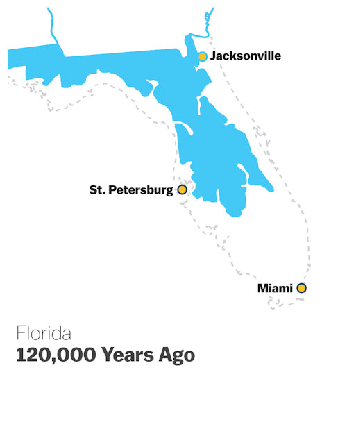
Such measures might stave off disaster in the short term, but the long-term outlook remains bleak. A geologic time-lapse video would show the Florida Plateau on which Miami is perched bobbing in and out of the Atlantic over the millennia: For a while it’s dry land; for a while it’s seafloor. At the peak of the last interglacial period about 120,000 years ago, Florida was a narrow, ragged stump reaching not much farther south than present-day St. Petersburg. By the time the most recent Ice Age reached its zenith 18,000 to 20,000 years ago, sea levels had dropped, and the peninsula had swelled to almost twice today’s width.
Since then, however, the world’s oceans have been creeping up again, helped along by human-induced warming. Along Florida’s west coast, where the first humans in the region settled about 10,000 years ago, archaeologists who study their villages have to wear scuba gear.
Harold Wanless, a professor of geology at the University of Miami, is well known around southeast Florida as the indefatigable Paul Revere of the climate crisis. According to Wanless, what many see as Miami’s worst-case scenario is actually a conservative estimate. Using the latest U.S. government projections, he is confident that the waters offshore will rise by more than the predicted two feet by 2048, three feet by 2064, and four to six-and-a-half feet by the end of the century. At six feet, more than half of Miami-Dade County will be submerged. The entirety of Miami Beach will be transformed from an island to a sandbar.
But problems will begin arising much sooner, even after a foot or two of rise. “Inland areas will see more and more days of flooding after big rains because drainage will become more and more sluggish,” Wanless said. “And we’ll be more and more prone to storm-surge damage from a hurricane.”
Another geologist, Peter Harlem of Florida International University, maintains that severe disruptions can result even from the kind of “nuisance flooding” that’s already occurring in some places and will spread to many more with even small increases in the sea level. “People don’t understand six inches,” Harlem said. “Six more inches can make life miserable here.”
In dealing with the Everglades on its western fringe, Miami faces a delicate balancing act. Freshwater flows out of the giant Lake Okeechobee in central Florida through the Everglades, and from there it pushes eastward underground to keep the Biscayne Aquifer filled. Were the aquifer to be ruined by saltwater intrusion, Miami would be doomed. So water managers adjust the flow from Okeechobee and the Everglades to apply back pressure against westward intrusion from the salty rising waters of Biscayne Bay.
But that vital water flow also complicates Miami’s future flood problems. “Around here, the flooding’s not just coming from the ocean. It’s coming from behind us,” said Henry Briceño, a research scholar at the Southeast Environmental Research Center at Florida International University. “We’re gonna get our asses wet—with water coming from the Everglades!”
In the longer term, pumps and fill dirt won’t be enough. Miami-Dade faces not one but four related flood threats. There is Miami Beach’s tidal flooding, which affects parts of the mainland’s coastal areas as well. There is the rainy-day flooding that increasingly plagues low-lying inland communities out west. There is the possibility of a big storm surge, a threat that looms larger with every inch of sea-level rise. And then, as the Atlantic continues to warm and swell, there is the long-term prospect of seawater pushing up from Biscayne Bay into glades and canals, flooding more and more of the city’s east side while backing up the whole hydrological system and causing the western suburbs of Miami-Dade to be permanently inundated from the Everglades side.
That last form of flooding will occur gradually over an extended period, but Harlem and his colleagues have modeled the end game: With a 2-degree Celsius rise in the global mean temperature, the Florida Keys, the entire Everglades, and all of Miami-Dade County will be submerged. That, they predict, will be the situation sometime after the year 2100—it’s hard to say exactly when.
For decades, Wanless, Harlem, Briceño, and other scientists met with frustration when trying to draw attention to the sea-level problem. Recently, however, as more and more Miamians have found themselves wading through the fallout of global warming, it’s seemed like everyone has been questioning the city’s future. A Rolling Stone headline waved, “Goodbye, Miami,” while The Guardian announced, “Miami, the Great World City, Is Drowning.”
It was just about the worst possible news for anyone connected to the pillars of the area’s economy: tourism and real estate. The city already had an effort going to pump the waters out of the storm drains, but more was needed. So in February 2014, the city commission voted to create a beefed-up flood-prevention infrastructure. That new plan, under which Mowry was installing all those new pumping stations, backflow prevention valves, and other features, would cost $400 million over five years, doubling the price tag of the city’s existing flood plan. Even more money would be needed to cover the massive costs of the many other planned flood-prevention projects, including the extensive road-raising.
The pumps installed in 2014 achieved a large reduction in flooding during the October king tide, and a surge of relief swept over the island. Nicole Hernandez Hammer, a climate researcher with the Union of Concerned Scientists, said the director of the Environmental Protection Agency and a contingent of U.S. senators had come to see the flooding, but the pumps had done their job. “It was like, ‘Ah, OK, I guess they took care of it,’ and they went home,” she said. But that small success masked the bigger problem lurking in the background. “Look at the hundreds of millions of dollars spent to prevent just this little bit of flooding,” she said, “which is only a small fraction of what we’re going to see in 30 years.”
It didn’t take long for Hammer’s fears to be confirmed. This September, a so-called supermoon, a full moon at its closest orbital approach to Earth, produced not only a striking photo opportunity but also three days of especially high king tides in southeast Florida. Mowry’s efforts spared the southwest portions of Miami Beach, but many other parts of the island suffered severe flooding, prompting calls to extend the raising-and-pumping project throughout the city.
What can Miamians expect in the coming decades? Harlem thinks in terms of a five-stage timeline. In stage one, only the lowest-lying areas, mostly out-of-sight, out-of-mind natural landscapes, flood frequently. In stage two, more private property is affected. He says Miami-Dade County is now passing from stage one to two. In stage three, the majority of people become affected; at that point, sea level becomes a political issue and collective action will replace individual responses. Impacts become increasingly dire in stage four, until the region arrives at stage five, when the only exposed land in Miami-Dade County and neighboring Broward County to the north will be a string of islands inhabited by a relatively small population of easygoing but hardy hurricane veterans—a place Harlem has nicknamed “Margaritaville.”
As the years wear on, South Florida municipalities with the highest property values and the most solid tax bases will follow Miami Beach’s lead—pumping, raising, and armoring. Other places may be considered expendable. Here is how University of Miami architecture professor Elizabeth Plater-Zyberk has predicted that state and county funding for dealing with rising waters will be allocated. “It’s going to have to be a political-economic question, and you’re going to say, ‘What is the most meaningful to us in terms of economic development and the GDP of the region?’ And everyone would say, ‘Well, the airports, the port, the tourist industry, that means the islands, our white-collar downtowns,’ and you’ll start thinking about what to do for those,” she said during a 2013 panel discussion on Miami public radio station WLRN. “The shopping centers or the houses that are, let’s say, out west, very low density—water will be coming up there as well ... generally speaking, affecting the economy minimally. Those are the places that you might decide to give up.”
One such place “out west” is Sweetwater, a small suburban town that sits just north of Florida International University, at three feet above sea level. Eight-and-a-half miles to the west, the Everglades begin. Under Sweetwater’s modest streets and lawns runs the constant eastward subterranean flow of fresh water from the Everglades, sustaining the aquifer under Miami. Sweetwater floods with every hard rain, and the reason is obvious. Walk along one of its residential streets, look through one of the many metal grates embedded flat in the asphalt, and there is the water table—not far down, partially filling the system’s lateral conduits even during the dry season. With any significant rainfall, the drains fill instantly, and the streets flood.
Sweetwater’s population is 96 percent Latino, and its median household income is $34,000. Its small slab-on-grade houses are a world away from the pastel-trimmed condo towers overlooking Biscayne Bay. Plater-Zyberk is almost certainly right: It will be the condo towers, not Sweetwater homes, that will be protected to the bitter end.
Many have argued that the Army Corps of Engineers, which controls the level of fresh water in the Everglades, should raise the water level further, thereby increasing the flow eastward through the limestone under Miami-Dade County and pushing back more forcefully against the seawater that’s trying to intrude from the Atlantic. That would quickly flood low-lying towns like Sweetwater.
Philip Stoddard, the mayor of South Miami, a small municipality on the mainland south of downtown Miami, sees the reluctance to purposefully flood towns like Sweetwater as a threat to the water supplies of other communities, including his. “One foot of sea-level rise reverses everything,” he said. “After that, if they were to raise the freshwater level in the aquifer up to where it needs to be to keep seawater out, Sweetwater floods. And the Corps of Engineers isn’t allowed to do that. This one small community is going to cost us our water supply many years earlier than we’d lose it otherwise. But no one will do anything about it because of the politics.”
Are Plater-Zyberk and Stoddard right? If the fragility that is Greater Miami is to be preserved for a while longer, will there be no choice but to surrender Sweetwater and other communities to the Everglades? And if so, will there be any provision made for compensation and relocation? Will communities be able somehow to keep themselves intact, somewhere else on higher ground?
Hammer points out that if there is another monster hurricane, or when parts of Miami-Dade County simply become unlivable because of routine flooding and seawater intrusion, the economic impacts will of course run along class and color lines but may adhere just as closely to lines of home ownership. There will be something like a three-way split.
Renters can take their remaining possessions, leave, and find housing and employment somewhere else; they will suffer, but they won’t necessarily be wiped out. Affluent owners of properties, in places like Miami Beach or the city’s waterfront Brickell neighborhood, will also come out fine if they can absorb their uninsured losses or if their losses are only on second homes or investment properties. It’s middle-class and low-income families—often immigrants—who have saved, scraped together a down payment, and bought a small place of their own who will take the biggest hit.
Few people we talked with in Miami believed that the city they all know and love would remain intact into the deep future. The question was not whether people will have to leave but when. When people ask Stoddard, “When should I think about selling my house?” he said he tells them, “It depends on whether or not you can afford to lose the capital in it. What happens to you? Are you ruined financially? It’s a question of risk tolerance. If you can afford to lose the capital in your house, keep it. Enjoy yourself! But if you’re counting on that house for retirement, or if you’ll end up destitute if you lose it, I say now would be a good time to sell your place.”
With a seemingly insoluble predicament looming, there is much talk around Miami of embracing the water by becoming more like Venice, Italy, a city that has in recent decades been attempting to protect its canal-laced urban area with a huge flood barrier. Wanless isn’t impressed. “Venice now has one-third the population it used to have,” he said. “No Sandy, no Andrew, no Katrina, just rising seas, increasing frequency of flooding, rotting, disruption of infrastructure—that’s made it an unpleasant place to live.”
Stoddard would like to see what’s often called “managed retreat”: devising a schedule to take land lying one foot, then two feet, then three, then four, above the current sea level and turn it over to aquatic parks, protective wetlands, or other uses. As part of this process, cities, counties, and the state could buy out homeowners in affected areas. Stoddard prefers the term “rolling easements,” because, he said, “Americans hate the word retreat.” Today in Miami’s political circles, he doesn’t see as much resistance to the idea itself as he once did. “No one’s even wincing now when you bring it up,” he said.
He expects the Miami that remains above the floodwaters decades from now, if it has managed to remain viable, will have abandoned its famed flashiness, excess, and bravado to adopt a culture more like that of the Florida Keys. “Down there, people just accept storms and floods as part of life,” Stoddard said. “They just board their houses up and ride it out. If we go the way of the Keys, the place will be a lot funkier, no longer the playground of the rich. But it could save the tourism economy—except of course they’d have to keep resupplying the beaches with sand.” If the city’s future does end up looking like Stoddard’s funky mini-Miami or Harlem’s Margaritaville, that will mean that old Keys have already gone under the waves, and Miami-Dade County has become an archipelago: the New Florida Keys in both geography and culture.
For now, though, most Miamians—even those who see clearly what’s coming—want to stay and make the most of a place they love. “Even before we’re underwater, within just 20, maybe 30 years, the salt water’s going to get these trees,” Mowry told us back in leafy Flamingo Park, pointing up. He couldn’t stomach the thought. “We just can’t make that sacrifice,” he said. “We’ll have to put our trees up in planter boxes.” Sitting on his back porch, 10 feet above sea level, Stoddard said, “At some point this house will be impossible to sell. I could get a good bit for it right now. Maybe I should sell it and move to the hills. … Then I also think how pretty this yard is.” Even Wanless, one of the most vocal on the climate emergency, agreed. “Compared with whatever is going on up in the rest of the country, this is just a wonderful place to live,” he said. “We’re all going to enjoy it as long as we can.”